THE PROJECT is riding every street in Annapolis. It’s been a great way to truly understand the development patterns and styles throughout the city and the resulting character of neighborhoods. This is actually a pretty common idea as I have a friend who did a similar thing (in a much larger area in California), as well as Internet cycling personality Sam Westby doing every street in Boston and a planner in the City of Cleveland who is running Every Street Cleveland. Ultimately, it was 130 miles of streets in a city that is just eight square miles!

My main motivation to do this is as a member of the Annapolis Planning Commission. I have been in Annapolis for 30 years and get around the city mostly walking or on a bike so have seen a lot of it. But, I am a creature of habit so I end up riding the same basic routes to places I go on a daily basis. You can see from my Strava heatmap below that I do the same thing most of the time as dark lines are my usual routes and the light colors are really mostly from this project.

Couple that with Annapolis being a “nooks and crannies” kind of place due mostly to the small peninsulas, there are a lot of neighborhoods I had never been to. So much of understanding a city is knowing it on the ground. As Jane Jacobs wrote in the essay “Pavement Pounders and Olympians” (from Vital Little Plans) the only way to really understand how a city works is to experience it on the ground. In it she contrasts two types of urban planners and their perspectives on cities. The “Olympians” (such as Robert Moses) are planners who view cities from above, imposing large-scale, top-down designs often ignoring the everyday experiences and complexities of urban life. In contrast, the “pavement pounders” are those who live in the city, walking its streets, experiencing it from the ground level, and understanding the intricate social fabric and spontaneous activities that give cities their vitality. For me, this project was very much a “pavement pounding” exercise.
It was really fun (most of the time – riding on Aris T Allen not so much) and I got to see not only every neighborhood, but also a bunch of areas that I thought were really just parking lots or private areas (more on this in the tech section below) that are one way in/out, mostly around the plethora of apartment and townhouse developments around the city. These are definitely places you would never experience and never have an understanding of the scale unless you knew someone there that you were visiting, for example Annapolis Overlook off Forest Drive.
A general observation is that most neighborhoods or in some cases collections of neighborhoods all have a fairly unique character, not so much design wise, but in their development pattern or layout. However, within that generalization, there are general similarities between neighborhoods based on the era in which they were developed. One of the first blog posts I ever wrote was about that and the key thing is the development pattern is indicated by the street layout and when the areas were annexed into the city:


Other observations are that in areas that are pre WWII, in addition to single family houses there a very large number of duplex, triplex, other multifamily housing and ADUs and a mix of uses, mostly now nonconforming since they predate our zoning code (see @missingmiddleannapolis for an exposé) and are very dense and walkable because they predate the automobile. These are neighborhoods like Murray Hill, Eastport (the peninsula anyway), and Germantown, Homewood and West Annapolis to an extent. The older single family house neighborhoods that were developed post WWII are all mostly very modest size houses on large lots because at the time land was cheap and buildings were not, places like Tyler Heights, Heritage and much of Parole among them. In much newer single family neighborhoods like Kingsport (at the end of Bywater Rd) and Preserve (off Forest Drive near Hillsmere), the lots become a bit smaller with much larger and generic suburban style houses as the equation has flipped with land being the most expensive commodity so the incentive is much more lot coverage. And of course some neighborhoods are in the process of changing – you could call it gentrification I suppose – as land values increase dramatically and the perverse incentives in the housing market of the last 25 years drive up values so much that we see much more lot coverage either with more units or extremely large, expensive houses on smaller lots. None of this is by chance, it’s all due to economic factors and city zoning policy, essentially what I talked about in my 2025 Ignite Talk. I didn’t do a great job of documenting examples while I was riding because in reality, this has been a 5 year project that just sort of happened organically and I never even thought about documenting it until recently.
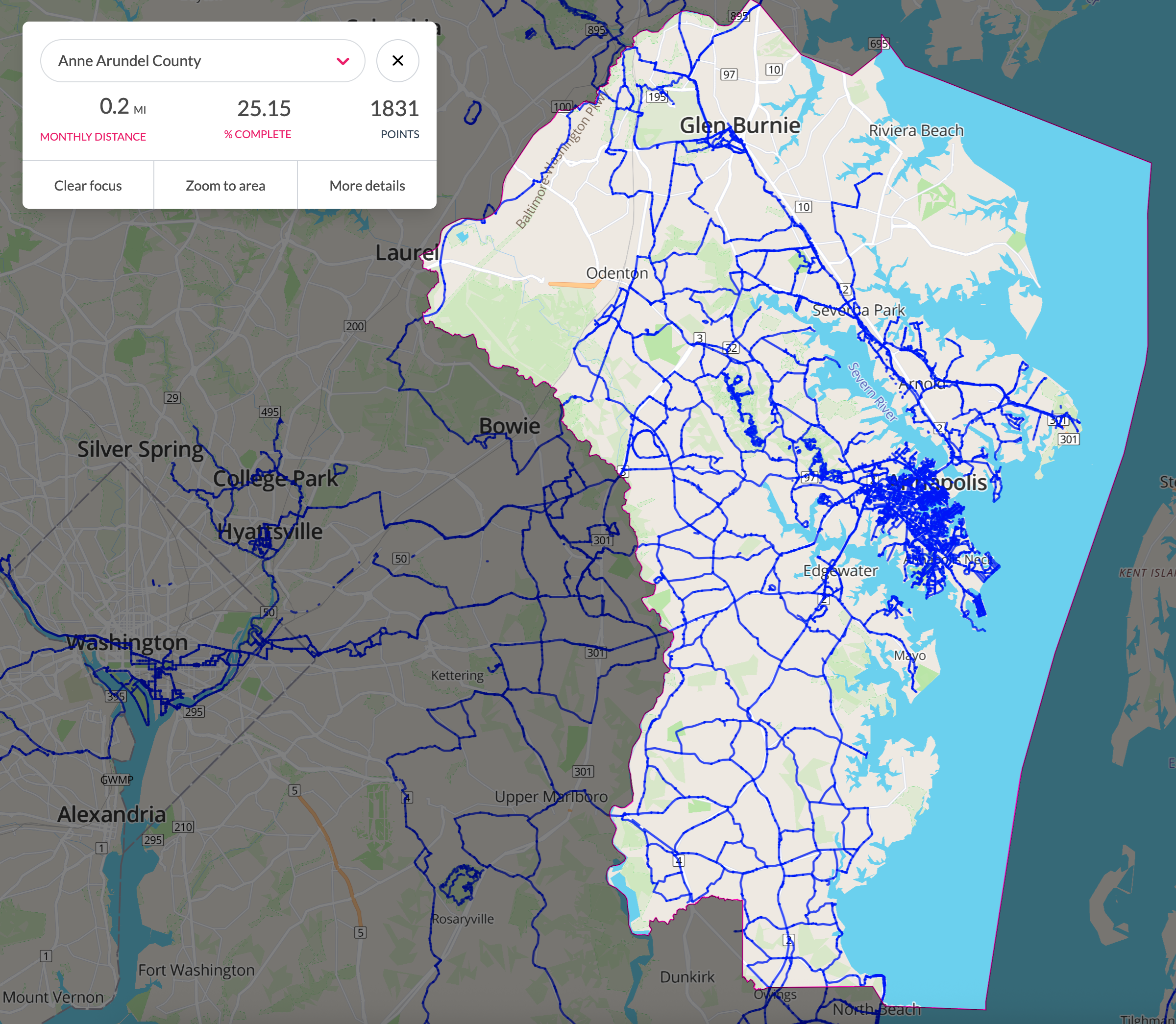
As to the technical details of how I tracked my progress, I used two online tools. I record all of my bike rides whether they are for transportation, recreation, or bike racing on the app Strava because I’m a data nerd. I have data back to about 2012 but my riding here goes back another 10 years, it’s just pre GPS bike devices so no record of them. I typically record these on my Garmin head unit (when on a “spandex” ride) or via the Strava app on my phone (when on a “street clothes” ride). The GPS accuracy/update rate of the phone app is not great so often causes me to miss record a short section that I have to go back to eventually. While Strava has the heatmap of where you’ve been, it’s not a great tool to actually track statistics for something like this. So I use a site called Wandrer that imports Strava/Garmin data and keeps track of how much of a geographical area you have covered and highlights the traveled/not traveled streets in different colors, making it easy to see what you’ve done, and importantly not done.
One issue with Wandrer is it uses Open Street Map (OSM) as it’s underlying street data rather than something like Google Maps. In general OSM is very “permissive” in terms of what it considers public streets as it emphasizes local knowledge and is community driven/crowdsourced. Contributors use aerial imagery, GPS devices, and low-tech field maps to verify that OSM is accurate and up to date. As I mentioned above, there are sections it considers “public” that are often in a gated community and it considers many parking lots or private community roads as “public” in the sense that they are available to anyone to access (some have “PRIVATE KEEP OUT” signs) but are not streets owned by the City of Annapolis. All of this is a bit arbitrary for the purposes of this project, but you have to use some scheme for what is an “Annapolis Street” and this is as good as any and has the advantage of having you do more rather than less compared to useing a scheme like “any street that has Google Street View”, ie can be publicly accessed by the street view car. So when I say there are 130 miles of streets in the City of Annapolis, that is likely a larger number than the data the City Department of Public Works considers streets they “own” and have to maintain.
How much I actually had to ride to accomplish riding the 130 miles is unknown since I did this over a long period of time, but consider that even if you are as efficient as possible, many places are one way in and one way out so you end up riding at least twice the distance you “rack up” for the trip, and that doesn’t include the distance you ride to get there and back. Towards the end, I often rode 20-30 miles with only 2-3 new miles max, and sometimes only a fraction of a mile of new streets per ride because I was pretty haphazard about it. And some of it was really not fun (Forest Drive, Aris T Allen et al). And if I am being completely honest, I did cheat under two circumstances: one, if there was a small section behind a gate that I could not easily or legally get to and two, if I did actually ride there, but the GPS was not accurate enough to record it (often from my phone). The latter happened if I rode on a sidewalk and it recorded too far off the location on OSM. In both of these cases, Wandrer lets you edit a track to correct these, but only if it is less than 2% of the entire ride, so it does limit how much you can cheat. I did this because while it doesn’t really matter conceptually, I am just OCD enough that I had to have a metric of 100% complete! And it took me almost 50 miles of riding to get the last 0.2 miles, I had to walk over the bridge across College Creek on the USNA campus (not allowed to ride bikes at USNA and it considers just that bridge part of Annapolis) and then I stopped to ride the trails in Truxton Park after my cyclocross race (I was kitted up with that bike so what the hell) to get the last 0.023 miles to get to 100%.


Next, I’m going to see how far I can get with Anne Arundel County, but even though I have completed 25% of it (3230 miles total in the County!) it will take a loooong time… But hey, this is the silly stuff retired guys have the time (sort of) to do.